Simple C# Console Application demonstrates how to programmatically utilize the Grok API with Live Web Search.
Below I am structuring a question pattern into a JSON payload. Then using an HTTP Client to submit the payload to Grok’s endpoint https://api.x.ai/v1/responses. Result content is then parsed, sanitized, and displayed.
Model used grok-4-1-fast-reasoning
Temperature used 0.0
This example:
Uses HttpClient
Sends a Grok chat request
Enables web search
Prints the final response
Full working C# Console App example that calls Grok (xAI) API and sends a JSON payload enabling web search. Must replace (Your-Grok-API-Key), with your own key.
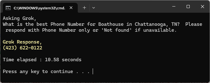
using Newtonsoft.Json; using Newtonsoft.Json.Linq; using System; using System.Collections.Generic; using System.Linq; using System.Net.Http; using System.Reflection; using System.Text; using System.Text.RegularExpressions; using System.Threading.Tasks; using System.Xml; using Formatting = Newtonsoft.Json.Formatting; namespace Grok_API_WithWebSearch_Skip_Tracing { internal class Program { static async Task Main(string[] args) { ///////////////////////////////////////////////////////////////////// //SKIP Trace automation example using GROK API with Live Web Search// //Model: grok-4-1-fast-reasoning///////////////////////////////////// //This program uses Nuget Package: Newtonsoft.Json/////////////////// ///////////////////////////////////////////////////////////////////// string apiKey = "(Your-Grok-API-Key)"; // <-- Replace this with your key string endpoint = "https://api.x.ai/v1/responses"; //Structure your question// //"What is the best Phone Number for [Business Name] in [City], [State], [Zip]? Please respond with Phone Number only or 'Not found' if unavailable."// string question = "What is the best Phone Number for Boathouse in Chattanooga, TN? Please respond with Phone Number only or 'Not found' if unavailable."; Console.WriteLine("Asking Grok,"); Console.WriteLine(question); Console.WriteLine(); //Create JSON payload// var payload = new { model = "grok-4-1-fast-reasoning", input = question, tools = new object[] { new { type = "web_search" } }, tool_choice = "auto", temperature = 0.0 }; string jsonPayload = JsonConvert.SerializeObject(payload, Formatting.Indented); //Start Timer// DateTime start_time = DateTime.Now; using (var client = new HttpClient()) { client.DefaultRequestHeaders.Add("Authorization", $"Bearer {apiKey}"); var content = new StringContent(jsonPayload, Encoding.UTF8, "application/json"); HttpResponseMessage response = await client.PostAsync(endpoint, content); string result = await response.Content.ReadAsStringAsync(); try { JObject parsed = JObject.Parse(result); var outputArray = parsed["output"] as JArray; string assistantText = null; foreach (var item in outputArray) { var contentArray = item["content"] as JArray; if (contentArray != null) { foreach (var block in contentArray) { if ((string)block["type"] == "output_text") { assistantText = (string)block["text"]; break; } } } if (assistantText != null) break; } if (assistantText != null) { // Regex pattern for phone number (simple US-style) string phonePattern = @"\(?\d{3}\)?[-.\s]?\d{3}[-.\s]?\d{4}"; // Extract Phone Number// Match phoneMatch = Regex.Match(assistantText, phonePattern); string phoneNumber = phoneMatch.Success ? phoneMatch.Value : "Not found"; //Output Phone Number// Console.ForegroundColor = ConsoleColor.Yellow; Console.WriteLine("Grok Response,"); Console.WriteLine(NormalizePhoneNumber(phoneNumber)); Console.ResetColor(); Console.WriteLine(); //Stop Timer// DateTime end_time = DateTime.Now; Console.WriteLine("Time elapsed : " + (end_time - start_time).TotalSeconds.ToString("F2") + " seconds"); Console.WriteLine(); } } catch (Exception ex) { Console.ResetColor(); } } } //Mehtod for formatting phone number structure variance// static string NormalizePhoneNumber(string input) { //Remove all non-digit characters// string digits = Regex.Replace(input, @"\D", ""); //Ensure it has 10 digits// if (digits.Length != 10) throw new ArgumentException("Phone number must have 10 digits after removing formatting."); //Format consistently: (###) ###-####// return $"({digits.Substring(0, 3)}) {digits.Substring(3, 3)}-{digits.Substring(6, 4)}"; } } } |